

This winter saw high temperatures and poor precipitation. Mass evaporation further dried out fuels. Only a very strong El Niño could help avoid repeat next year.
THE GORGE — While last week's showers brought a temporary reprieve, Oregon and Washington still face historically low snowpack and impending drought as a longer wildfire season begins; however, there might be some hope at the end of this climate-change-driven tunnel.
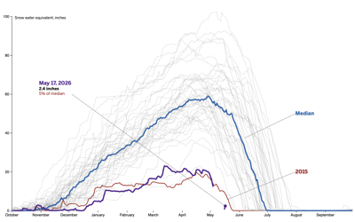
As of press deadline, Washington is under a statewide drought emergency while 12 counties, stretching from southwest to northeast Oregon, have made similar declarations. Apart from two, the amount of water stored in snowpack, otherwise called snow water equivalent (SWE), is less than 50% of the historical average for all major basins across both states, according to May 15 numbers from the Natural Resources Conservation Service.
In fact, just east of The Dalles, the John Day Basin has completely melted out, and Mount Hood’s SWE at one test site is currently the lowest it’s been since data collection began in 1980. The National Interagency Coordination Center predicts significant wildland fire potential east of the Cascades by June, with the entirety of Oregon and Washington under elevated risk come August.
“In Oregon, we were tied for the [second]-warmest winter on record going back to 1895,” said State Climatologist Larry O’Neill. “We were something like six degrees Fahrenheit above normal, and that was relative to the 20th-century average. Whatever precipitation we got fell as rain rather than snow, for the most part.”
As previously reported by Columbia Gorge News, two atmospheric river systems hit the Gorge in mid-December. Although streams swelled and some areas saw flooding, Mt. Hood Meadows didn’t get a boost because temperatures never dropped, forcing the resort to open just before Christmas — another record.
According to O’Neill, last April to March was also the sixth-driest 12-month period that Oregon has experienced, again since 1895. Washington saw better winter precipitation, particularly in the North Cascades and Puget Sound area, but a regionwide warm, dry spring followed, causing the already-meager snowpack to diminish faster than normal.
“That means the landscape will get to its typical summer dryness about one to two months earlier, barring any miracle storm,” O’Neill said on May 6. “It basically will just extend fire season by that much.”
Locally, Columbia Gorge News staff received the first report of a quickly extinguished wildfire on April 10. The Pine Mountain Fire, sparked by a prescribed burned 2,569 acres southeast of Bend that has since been extinguished, was declared a wildfire on May 7, marking Oregon’s first major incident this season.
With natural reservoirs depleted, poor springtime recharge and continued high temperatures, the Pacific Northwest has already experienced what O’Neill calls a “mass evaporation event.” Warmer atmospheres can hold more water vapor — they demand it — sucking whatever moisture is left from the soil, crops, trees and water bodies.
Snowpack usually keeps water in the environment for longer and reflects sunlight back toward the atmosphere, moderating temperatures at higher elevations, and its absence paves the way for more evaporation. Looming over this positive feedback loop is climate change.
“This has been part of a trend that we’ve seen over the last 30 or 40 years: declining snowpack in much of the U.S. West,” said O’Neill. “There might be some natural variability associated with that, like ocean temperatures, but a big part of it is driven by general warming.”
Although recent cooler temperatures and rain staved off further drying, warmer, drier and sunnier conditions will return this week for most of the state and will likely continue for the rest of May. As a result, O’Neill is confident that evaporative demand will return to being well above normal.
Beyond wildfire risk, where fuel moisture plays an important role, he noted that agriculture and hydropower generation will probably suffer because of reduced stream flows. In summer 2015, when Oregon and Washington had similarly lackluster snowpack, electricity via dams fell roughly 32% compared to the previous five-summer average.
Looking into this winter, however, O’Neill is cautiously optimistic about a rebound.
According to the National Weather Service’s Climate Prediction Center, it’s 98% likely that an El Niño pattern will emerge in August, September or October. Characterized by warmer ocean waters in the central and eastern tropical Pacific, which then influence jet streams nationwide, moderate or strong El Niño events typically bring warm, dry winters to the Pacific Northwest.
But for Oregon specifically, a very strong El Niño could mean the inverse. Three have occurred since the early 1980s, O’Neill said, and two of those winters saw higher-than-average precipitation, snowpack and even some flooding. Currently, there’s a 37% chance that a very strong El Niño will form in October, November or December.


Commented