SOUTH WASCO — While the human-caused Larch Creek Fire had grown to 18,486 acres by July 15, with an estimated cost of $7,100,000 at last announcement, no lives or structures had yet been lost.
Any updates announced after press deadline on July 15 can be found online at columbiagorgenews.com.
At eight percent containment, the fire has drawn personnel and resources from across Oregon, following an emergency declaration by Gov. Tina Kotek a few hours after the conflagration started.
The fire was begun by human activity around 2 p.m. on Tuesday, July 9. Landowners and fire departments responded to the initial 7,100-acre wildfire, which burned grass and timber near Friend, Oregon. They focused on protecting lives and structures, which needed varied methods — fire lines, hose lays, and air attack. One firefighter was transported to a hospital for heat-related injuries.
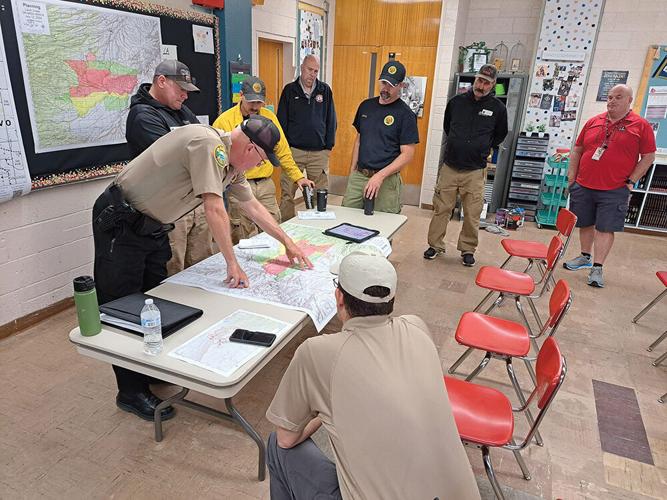
Kotek invoked the Emergency Conflagration Act on the evening of Tuesday, July 9, allowing more support to assist local emergency responders. Oregon State Fire Marshal (OSFM) brought four structural task forces and its Green Incident Management Team, which joined the Central Oregon Interagency Management Team in command July 11, according to a press release.
The fire grew fast, burning east, driven by high winds. But winds began to slacken over the next few days, allowing crews to make more headway.
Local landowners fought the early stages of the fire with their own resources, “really stepping up” to put out spot fires and help fight the blaze, said Andy Dwyer, Oregon Department of Forestry (ODF) public information officer trainee. In the early stages of the fire, Dwyer noted many locals “fighting fire right alongside the agency people.”
“We really appreciate the community support and their thoughtfulness during the emergency,” said Wasco County Sheriff Lane Magill. “I also really appreciate all the fire agencies’ assistance and support for our citizens.”
Communities in Tygh Valley, Wamic, Pine Hollow, and Sportsman’s Park were evacuated by WCSO deputies, livestock and all — although one Tygh Valley diner reopened, safe but still under "Go Now" orders, to feed firefighters for free.
By July 10, the winds fell and the fire’s growth slowed. Bulldozers working through the night made progress creating control lines and engines patrolled near homes in the fire area.
Some spot fires had appeared in the Oak Creek area that day, July 10. Spot fires happen when embers rise from the main fire, going up with the smoke, then fall onto another area, starting small solitary blazes, Dwyer said. Firefighters try to hunt down and control any spot fires they can find.
Firefighters made hose lays, and worked with engines and water tenders to build control lines. This often means clearing a fireline with a bulldozer, then “plumbing” it with a hose so that water can be piped in to protect a structure, said Dwyer.
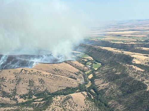
A look at the Larch Creek fire from the air.
Rich Saalsaa photo
A red flag warning for extreme fire danger covered the fire’s region for the first few days, according to the National Weather Service. And another red flag warning for critical fire weather, with winds gusting up to 26 miles per hour according to National Weather Service data, went into effect July 14 on the fire’s east side.
This means the ongoing heat wave, low humidity and breezes coming through the Cascades increased the risk of fire. Temperatures reached 107 degrees Fahrenheit on Tuesday, July 9, according to OSFM.
Some private persons began doing their own defensive burning, setting patches of landscape on fire unannounced and complicating decisions on evacuation levels, Wasco County Sheriff Lane Magill said this weekend. He asked that anyone interested in defensive burning communicate with fire personnel and Incident Command before burning, and reach out to him if that fails.
Drones are forbidden from flying in the fire area, because they could ground all the aircraft fighting the blaze.
Other responding agencies are ODF’s Central Oregon Distirct, U.S. Forest Service, and local fire districts including Dufur, Wamic and Tygh Valley.
Despite the cost estimate of over 7 million, no structures have been lost to the fire, Krell said on July 15.
The blaze had drawn 944 firefighting personnel, 66 fire engines, 18 water tenders, ten helicopters and 13 bulldozers by then.
Two shelters took in people, South Wasco County High School and Wy’east Middle School, with fairgrounds sheltering displaced livestock and pets.
The fire jumped Highway 197 and headed east on July 11. Highways 216 and 197 both closed intermittently.
The winds were calmer on July 12, and with growing resources, crews made progress. The fire’s southwest remained challenging, with crews working in steep terrain and canyons. By Sunday, the fire was three percent contained, according to WCSO press releases.
The fire grew to 14,267 acres by July 14, driven by the dry fuel, and those initial high winds through the Cascades.
The next day, July 15, updated mapping technology got a better estimate of the fire’s footprint, at 18,486 acres. This includes the areas of controlled burns, said Stephanie Krell, Wasco County public information officer.
The blaze was still just eight percent contained, with fire lines 100 feet deep around some areas.
“The heat wave that has gripped Oregon significantly increased the fire danger across the state. The continued hot, dry conditions, and gusty winds are a dangerous combination,” Chief Deputy State Fire Marshal Travis Medema said on July 9. “I am asking everyone to do what they can to prevent sparking a wildfire.”


Commented