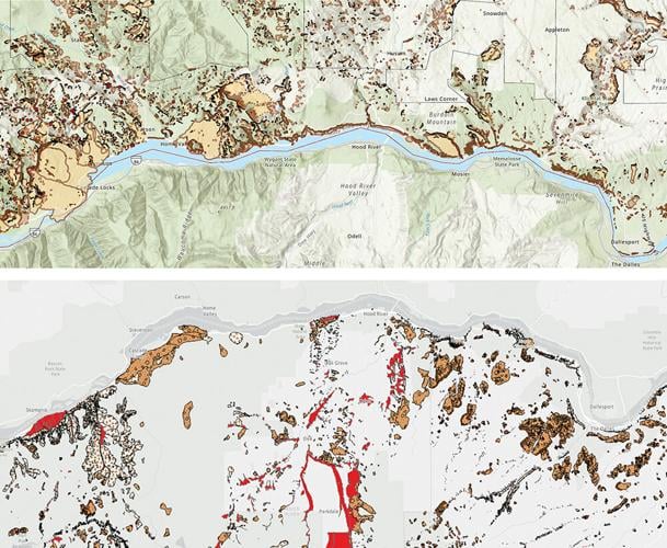
Two maps of previous landslides and debris flows on both sides of the Columbia Gorge. In the top image, red dots indicate recent landslides and events surrounded by a solid border are known with high confidence. In the bottom image, light brown areas denote known landslides while the speckled and red areas represent two different types of debris deposits.
Photo courtesy of Washington’s Department of Natural Resources and Oregon’s Department of Geology and Mineral Industries
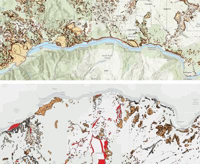
HOOD RIVER — Richard Iverson, scientist emeritus at the U.S. Geological Survey’s (USGS) Cascades Volcano Observatory, dove into relatively recent geologic time at the Columbia Center for the Arts on Nov. 13. The latest showing of "Sense of Place" Season 15, curated and hosted by Sarah Fox, Iverson unpacked the processes behind and risks posed by hazards in the Columbia Gorge.
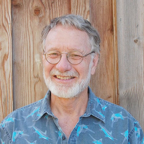
Richard Iverson, Cascades Volcano Observatory
Part of the Mt. Adams Institute, "Sense of Place" is a long-running series featuring presenters who instill a deeper connection between people and landscape. The Gorge is an incredibly active, young region geologically speaking, home to landslides and debris flows, volcanic eruptions and earthquakes. Inextricably tied to natural beauty, Iverson sought to educate locals about the churning, splitting earth beneath our feet.
“I don’t think of the geologic hazards in the Gorge as being severe, but I do think of them as being significant enough that we need to pay attention to them, and in some cases, maybe take action in response,” said Iverson.
The Gorge is rife with landslides and debris flows, two similar but distinct types of downslope earth movement, with the latter having a higher water content and generally moving at faster speeds. Exacerbated by steep elevation and weakened rock, many people think earthquakes cause landslides and debris flows, but the main factor is precipitation.
“When things have been particularly wet, that’s when landslides are more prone to moving simply because the water pressure underground is pushing against the soil or rock particles, and thereby reducing the frictional contact forces between those particles,” said Iverson. “That’s what enables the material to slip and slide.”
In Oregon, there have been previous landslides above Cascade Locks, near the Mitchell Point area and along the Historic Columbia Gorge Highway east of Hood River. In Washington, Iverson said Stevenson is built almost entirely on an old landslide and pointed out that Bingen experienced a landslide in 2009, caused by SDS Lumber and their mining operations.
“Where there is an old landslide present, assuming that it isn’t now completely flat ground, there’s always the potential for it to become reactivated,” said Iverson. He noted, however, that strong basalt rock found throughout the Gorge makes lethal, fast-moving landslides improbable.
As for volcanic activity, Iverson focused on Mount Hood and Mount Adams, which have been relatively quiet compared to others in the Cascade Range, but there has been more seismic activity near Mount Adams recently. In the past 4,000 years, both stratovolcanoes had just two major eruptive periods — for context, Mount St. Helens had more than a dozen.
Volcanoes present several different risks, but Iverson talked about what are called distal hazards: Those that occur or travel farther away from the source, such as debris avalanches and lahars, ashfall and volcanic vents.
Since Hood and Adams don’t have a history of explosive eruptions, unlike Mount St. Helens, ashfall isn’t a major risk. While volcanic vents can pop up essentially anywhere, the lava produced would move so slowly that it doesn’t present a huge risk either.
But debris avalanches and lahars, on the other hand, are. Mount Hood’s crater opens to the south, so most debris avalanches (primarily dry rock, other materials) and lahars (primarily volcanic debris and water, mud-like, rapidly moving) wouldn’t travel toward populated areas. About 6,000 years ago, though, a lahar from Mount Adams buried the entire White Salmon River Valley and a smaller lahar approached Trout Lake just 260 years ago.
Hot, acidic volcanic fluids have degraded a significant section of rock on the southwest flank of Mount Adams, aimed toward Trout Lake, which USGS has studied. Iverson said they’re currently developing a physics-basedmodel to better predict the actual behavior of a future Mount Adams lahar, rather than relying on statistical models, and explained how climate change increases the likelihood of such events.
“If you have much deeper snowpacks present,” said Iverson, “that snowpack tends to act as a sponge. When there’s heavy rain on top of it, instead of just releasing all the water, a lot of it ends up getting stored within the snowpack and then slowly released.” With less water to infiltrate rock, there's less instability.
Iverson touched on earthquakes last. Squarely within the Cascadia subduction zone, where the Juan de Fuca plate is gradually slipping beneath the North American plate, scientists estimate there’s a 37% chance of the Pacific Northwest experiencing a megathrust earthquake (7.1 magnitude or greater) in the next 50 years.
“I actually feel safer, from a geologic hazard standpoint, living here than I would if I was living in a big city like Portland or Seattle,” said Iverson. “Those big cities have so much infrastructure — so many important bridges — there’s so many things that can go wrong just due to the sheer volume of stuff that could be affected.”
Apart from “the big one,” Iverson highlighted that a much smaller fault, or crack in the Earth’s crust, runs through the Hood River Valley and into Washington. Called the Gate Creek Fault Segment, the trench has produced a magnitude 6 earthquake in the past, which would have released 32 times less energy than a magnitude 7, or 1,000 times less than a magnitude 8.
Iverson advised the audience to download the ShakeAlert app, an automated USGS system that will send out warnings seconds before strong shaking arrives so you can prepare. And even with all the hazards around us, he ended on a positive note.
“On balance, I feel like the benefits of living here — the scenery, the inspiration you can derive from the natural setting, all the recreational opportunities and so forth — I feel like it’s well worth living here,” said Iverson. “Although there are hazards, I don’t recommend anyone move away.”
•••
Our journalism needs your support. Become a subscriber at www.ColumbiaGorgeNews.com; click subscribe.


Commented