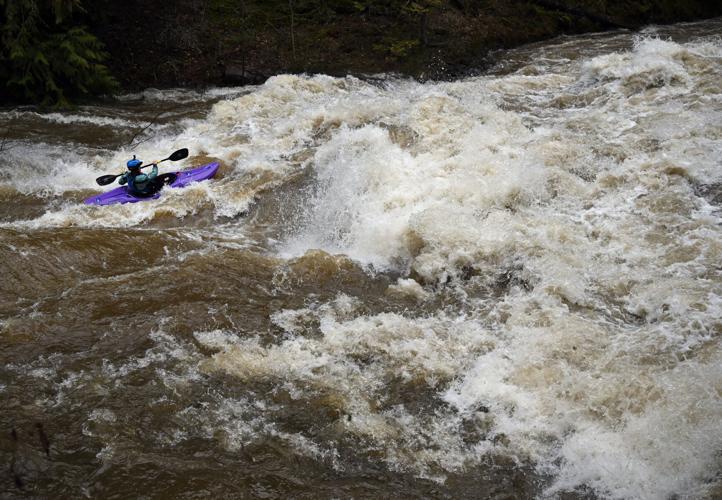
A kayaker runs through a class III rapid known as Maytag during peak flows on the White Salmon river during the atmospheric river in BZ Corner, Washington on Dec. 10. Maytag is a popular, “punchy” Class III rapid right at the put-in for the middle section of the White Salmon River. While generally considered a Class III, the rapid packs a punch and can feel like a IV at higher flows like those brought on by the recent weather system. The intense atmospheric river hit both Oregon and Washington bringing with it significant flooding, landslides, and record rainfall. While the main storm moved north, causing severe issues in Washington and B.C., Oregon saw major impacts, particularly in the Coast Range and Portland area. Forecasts are calling for more moisture and another potential system potentially stressing already saturated ground.
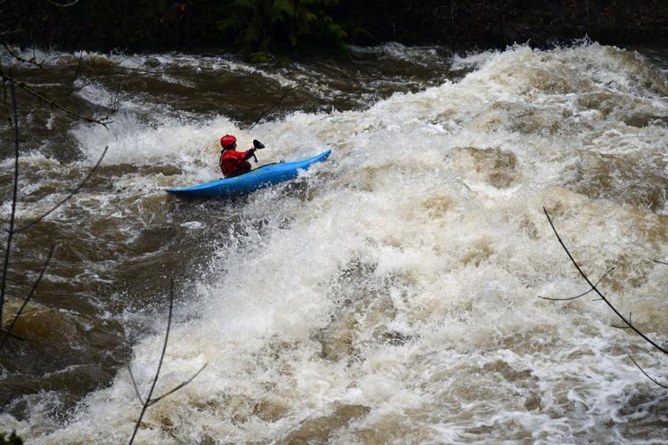
Kayakers Lily Wheeler, right, Whitney MacIntyre and their friends study the White Salmon river before running it in their kayaks near BZ Corner on Dec. 10. An intense atmospheric river hit both Oregon and Washington over the previous week, bringing with it significant flooding, landslides, and record rainfall. It also caused historic flows that excited kayakers, many of whom said they had never seen the rivers so high in years.
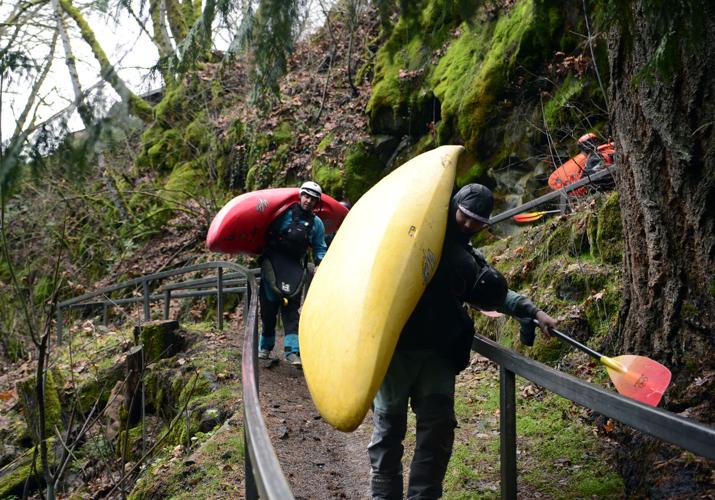
BZ CORNER, WASHINGTON: Kayakers head down to the river with their kayaks to take advantage of the big flows caused by the atmospheric river in BZ Corner, Washington on December 10, 2025. An intense atmospheric river hit both Oregon and Washington bringing with it significant flooding, landslides, and record rainfall. It also brought historic flows exciting kayakers, many of whom said they had never seen the rivers so high in years. While the main storm moved north, causing severe issues in Washington and B.C., Oregon saw major impacts, particularly in the Coast Range and Portland area. Forecasts are calling for more moisture and another potential system potentially stressing already saturated ground.
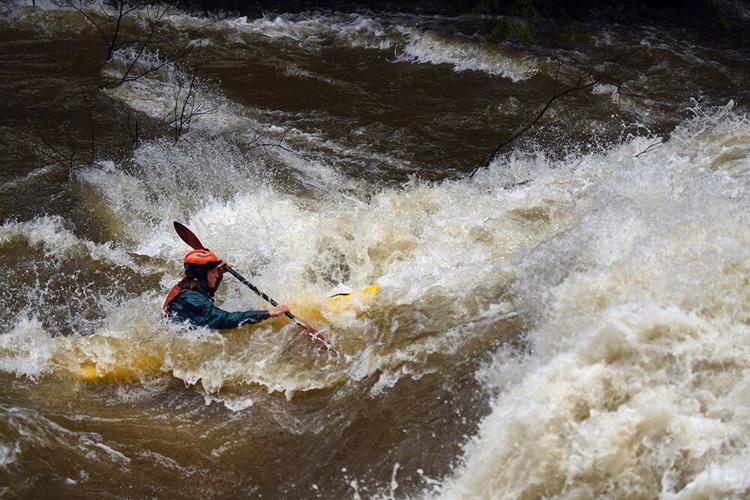
BZ CORNER, WASHINGTON: A kayaker runs through a class III rapid known as Maytag during peak flows on the White Salmon river during the atmospheric river in BZ Corner, Washington on December 10, 2025. Maytag is a popular, “punchy” Class III rapid right at the put-in for the middle section of the White Salmon River. While generally considered a Class III, the rapid packs a punch and can feel like a IV at higher flows like those brought on by the recent weather system. The intense atmospheric river hit both Oregon and Washington bringing with it significant flooding, landslides, and record rainfall. While the main storm moved north, causing severe issues in Washington and B.C., Oregon saw major impacts, particularly in the Coast Range and Portland area. Forecasts are calling for more moisture and another potential system potentially stressing already saturated ground.
BZ CORNER, WASHINGTON: A kayaker runs through a class III rapid known as Maytag during peak flows on the White Salmon river during the atmospheric river in BZ Corner, Washington on December 10, 2025. Maytag is a popular, “punchy” Class III rapid right at the put-in for the middle section of the White Salmon River. While generally considered a Class III, the rapid packs a punch and can feel like a IV at higher flows like those brought on by the recent weather system. The intense atmospheric river hit both Oregon and Washington bringing with it significant flooding, landslides, and record rainfall. While the main storm moved north, causing severe issues in Washington and B.C., Oregon saw major impacts, particularly in the Coast Range and Portland area. Forecasts are calling for more moisture and another potential system potentially stressing already saturated ground.
A kayaker runs through a class III rapid known as Maytag during peak flows on the White Salmon river during the atmospheric river in BZ Corner, Washington on Dec. 10. Maytag is a popular, “punchy” Class III rapid right at the put-in for the middle section of the White Salmon River. While generally considered a Class III, the rapid packs a punch and can feel like a IV at higher flows like those brought on by the recent weather system. The intense atmospheric river hit both Oregon and Washington bringing with it significant flooding, landslides, and record rainfall. While the main storm moved north, causing severe issues in Washington and B.C., Oregon saw major impacts, particularly in the Coast Range and Portland area. Forecasts are calling for more moisture and another potential system potentially stressing already saturated ground.
Aziza Cooper-Hovland
Kayakers Lily Wheeler, right, Whitney MacIntyre and their friends study the White Salmon river before running it in their kayaks near BZ Corner on Dec. 10. An intense atmospheric river hit both Oregon and Washington over the previous week, bringing with it significant flooding, landslides, and record rainfall. It also caused historic flows that excited kayakers, many of whom said they had never seen the rivers so high in years.
BZ CORNER, WASHINGTON: Kayakers head down to the river with their kayaks to take advantage of the big flows caused by the atmospheric river in BZ Corner, Washington on December 10, 2025. An intense atmospheric river hit both Oregon and Washington bringing with it significant flooding, landslides, and record rainfall. It also brought historic flows exciting kayakers, many of whom said they had never seen the rivers so high in years. While the main storm moved north, causing severe issues in Washington and B.C., Oregon saw major impacts, particularly in the Coast Range and Portland area. Forecasts are calling for more moisture and another potential system potentially stressing already saturated ground.
THE GORGE — Over the last week, torrential rains have occurred throughout Oregon and Washington, causing flooding, especially in Western Washington. The Gorge, while not as hard hit as further north, still saw heavy, warm rains and high, fast-moving water in the Hood River, White Salmon, and other tributaries that feed into the Columbia River.
According to the National Oceanic and Atmospheric Administration (NOAA) Water Prediction Service, observed flows on the White Salmon River peaked at 5:30 p.m. on Dec. 9, reaching 3730 cubic feet per second (CFS) — approximately enough to fill an Olympic swimming pool in 24 seconds — and cresting at 6.58 feet in height. By comparison, the White Salmon crested at 3.68 feet with flows of 680 CFS one week before on Dec. 3. The Hood River was much higher, cresting at 11.43 feet with 10,300 CFS on Dec. 10 at 2:45 a.m., as opposed to its usual 2.7 to 4 feet.
An atmospheric river — warm, moist streams of air from tropical areas that form over oceans — was the cause, and another event was expected in the Pacific Northwest early this week. While atmospheric rivers are common, accounting for 30-50% of the annual average precipitation in the Pacific Northwest and California, they dump all of their rain in a short amount of time, which can lead to large-scale flooding.
There are many aerial tributaries that contribute to the atmospheric river. Most in this area come from the Pacific, but at times, a more northern tributary can connect to it, and dump masses of snow rather than masses of rain. The Pacific Flow is often called the Pineapple Express due to its origination around Hawaii.
BZ CORNER, WASHINGTON: A kayaker runs through a class III rapid known as Maytag during peak flows on the White Salmon river during the atmospheric river in BZ Corner, Washington on December 10, 2025. Maytag is a popular, “punchy” Class III rapid right at the put-in for the middle section of the White Salmon River. While generally considered a Class III, the rapid packs a punch and can feel like a IV at higher flows like those brought on by the recent weather system. The intense atmospheric river hit both Oregon and Washington bringing with it significant flooding, landslides, and record rainfall. While the main storm moved north, causing severe issues in Washington and B.C., Oregon saw major impacts, particularly in the Coast Range and Portland area. Forecasts are calling for more moisture and another potential system potentially stressing already saturated ground.
Helen H. Richardson
The outlook
Preliminary findings show that Hood River and the surrounding area has had an unprecedented week on several meteorological fronts: Record high temperatures for three days and 15 inches of rain fall on Mount Hood Meadows by Wed. Dec. 10, according to data from Temira Lital, local weather forecaster, which neared the weekly historical record.
“These events aren’t out of the bounds of normal. [They occur] over the course of time with relative frequency, but some areas of the northwest really got hammered by this particular atmospheric river, especially up north,” Lital said.
“The Pacific Northwest is forecast to be hit by a series of atmospheric rivers beginning Sunday night and stretching into at least Thursday that are also forecast to be moderate or strong,” said Larry O’Neill, associate professor of Earth, Ocean, and Atmospheric Sciences at Oregon State University, director of Oregon Climate Service, and the state’s climatologist. “We expect flooding to again be an issue in places throughout the Pacific Northwest, particularly in areas that received a lot of rain last week.”
Barbara Ayers, who heads Skamania County’s Department of Emergency Management, said that the different county agencies have been coordinating, and while not much damage was reported — some landslides and flooding, but no injuries — they are “worried” because of further the atmospheric rivers forecast in the coming weeks.
“We saw a lot of flow,” said Ayers about the local waterways. One of the factors that is concerning is the burn scars from summer wildfires, which increase the risk of landslides when the rains come without trees to support the soil, she said.
Another concern is the lack of existing snowpack on the mountains with this amount of rain. If there was already snow, it would easily absorb 15 inches of rain, but as it stands, there is no snow yet below about 10,000 feet, and without it, the ground won’t be able to retain or replenish the water levels properly.
BZ CORNER, WASHINGTON: A kayaker runs through a class III rapid known as Maytag during peak flows on the White Salmon river during the atmospheric river in BZ Corner, Washington on December 10, 2025. Maytag is a popular, “punchy” Class III rapid right at the put-in for the middle section of the White Salmon River. While generally considered a Class III, the rapid packs a punch and can feel like a IV at higher flows like those brought on by the recent weather system. The intense atmospheric river hit both Oregon and Washington bringing with it significant flooding, landslides, and record rainfall. While the main storm moved north, causing severe issues in Washington and B.C., Oregon saw major impacts, particularly in the Coast Range and Portland area. Forecasts are calling for more moisture and another potential system potentially stressing already saturated ground.
Helen H. Richardson
Local resources
If the forecast holds and people are looking for help, there are a number of local resources available.
“If there are impacts to the floods, we can be available [to assist within the scope of our work],” Underwood Conservation District Director Tova Tillinghast said, though there are currently no flooded areas that have requested assistance.
The EMS departments can also be notified, and people can make themselves more prepared to deal with inclement winter weather by signing up for local emergency alerts, preparing for power outages with flashlights and charged generators, gathering supplies both at home and in the car in case you’re caught out, and staying warm.


Commented
Sorry, there are no recent results for popular commented articles.