Sports editor’s note: This is a summer adventure series that will run periodically in the News, detailing a variety of ways to get outside and enjoy what the Columbia River Gorge has to offer. This is a revival of a previous summer column started by former sports editor Ben McCarty in 2006.
Like many people who live here, or visit here, I love hiking in the Gorge. As a native of the Finger Lakes region in Upstate New York — another area of the country renowned for its natural beauty — I was exposed to similar natural elements growing up: Ithaca, N.Y., less than an hour away from my hometown of Skaneateles, N.Y., has its gorges. About two hours in the other direction are the Adirondack Mountains. Both, however, pale in comparison to the gorges and mountains out here in both breadth and beauty.
But unlike many other Gorge denizens, I’m not hardcore about my hiking. I’ll probably never put on cramp-ons in my life and if I can’t do the hike in a day, then I probably won’t do that either. I want to see a great view, but I don’t want to spend a night in a tent to do it. Call me crazy, but I’m a big fan of using toilets.
Anyway, I recently crossed off one of those accessible kinds of day-hikes I’ve been wanting to do for a majority of the five years I’ve lived out here: Chinidere Mountain, which I would argue has one of the best, if not THE best effort-to-reward ratios when it comes to a view hike in the Gorge.
Chinidere Mountain is located in the Mark O. Hatfield Wilderness of the Mt. Hood National Forest, about 45-50 minutes southwest of Hood River (depending on how you drive and what you get stuck behind on your way up to the mountain). In addition to having an incredible, 360-degree-view at the mountain’s totally exposed, rocky summit, the trail for Chinidere starts at Wahtum Lake, providing an opportunity to cool off after your hike if you so choose. Bring a NW Forest Pass so you can park at the trailhead.
The hike is an easy to moderate 1.8-mile climb (for a 28-year-old male who’s in questionable physical condition), according to the Mt. Hood National Forest’s website, or about 3.5 miles roundtrip. It took me about two to two-and-a-half hours to do the hike, including plenty of time for water breaks, gawking, taking photos, and hanging out on the summit. There are a couple ways to reach the peak, all of which seem to wrap around Wahtum Lake, so consult the Forest Service’s website for both hiking and driving directions (http://1.usa.gov/1NzrSBO), or other websites like oregonhikers.org, or go analog with a guidebook. (I took the trail that heads right as soon as you walk down the steps from the trailhead/campground to the lake.)
Personally, I felt the drive was more strenuous than the climb, as the U.S. Forest Service wisely cautions visitors that the final road taking you to the trailhead (FS Road 13) is paved but narrow, with a decent amount of traffic in the summer months. I’d add that rock fall, blind corners, overgrown trees and bushes, and the occasional pitting of the roadway can make it fairly sketchy at times for white-knuckle drivers. Parking at the trailhead can be a bit tight on the weekends as well.
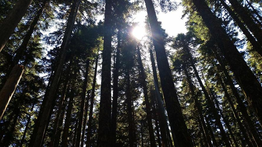
Starting at the shores of Wahtum Lake, the trail gradually ascends through the hills that ring the body of water, with glimpses of the lake visible through the trees. The trail is mostly hard-packed earth that’s not quite big enough for two people to walk side-by-side. The trail is broken up by tiny little brooks that quietly trickle on their way down to the lake. Thick, almost jungle-like vegetation (sorry, I’m no botanist) lines both sides of the path to Chinidere.
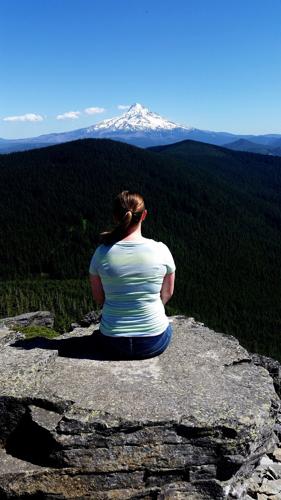
Eventually, the trail flattens out, passing through a forest of tall Douglas firs, the forest floor of which is filled with the white flowers of bear grass in late spring/early summer. In the last several hundred feet of the hike, the trail’s incline starts to kick it up a few notches, but a well-traveled talus slope soon signifies that the end of the trail is near. On the final leg of the switchback, the trail turns you around onto a wide ridge that serves as the mountain’s summit, and wham, an unobstructed view of Mt. Hood is lined up perfectly with the end of the trail.
On a clear day, the summit offers views of Hood, Adams, St. Helens, Rainier, Jefferson, Defiance, and probably plenty of other peaks that sharper eyes than mine could identify. Looking north, you can clearly make out the canyon of Eagle Creek and see straight down into the Columbia River Gorge near where Bonneville Dam is (I highly recommend bringing a pair of binoculars). Depending on the time of year, a variety of wildflowers dot the summit as well. An eastern-facing rock outcropping that lines up with Mt. Hood also provides great photo ops or a place to sit for some existential musings.
Head back down the way you came, or hook up with another trail that skirts the other side of Wahtum Lake. Wade in and cool off or head back up the stairs to the trailhead for another adventure.


Commented
Sorry, there are no recent results for popular commented articles.