
By Dan Spatz
For Columbia Gorge News
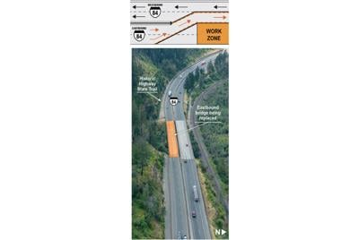
CASCADE LOCKS — Interstate 84 traffic jams are causing motorist frustration in the Columbia Gorge this summer, as contractors hired by Oregon’s Department of Transportation (ODOT) replace an aging bridge across McCord Creek.
A popular trailhead, McCord Creek is between Warrendale and Cascade Locks. There are two freeway bridges, one for each direction of travel. ODOT is replacing only the eastbound bridge, which was constructed in 1962 and does not meet current safety standards, according to David House, ODOT public affairs officer. Goals are to remove a longstanding “dip” in the road surface, improve safety and increase earthquake resilience.
Work is scheduled to conclude Oct. 31. Thus far, crews have installed new columns, abutments, retaining and wing walls; steel girders were scheduled for June 27. The old bridge has been demolished. House said ODOT had hoped to have two lanes in both directions open by the July 4 weekend, but a delay in Montana steel fabrication set this back to August.
“We try to keep major highways open in the summer for tourist season to the best of our ability, but some projects don’t allow that,” House wrote in an email to Columbia Gorge News. “Our target to have the [eastbound] bridge open to traffic is by the end of August, but there will be occasional lane and shoulder closures this fall as we continue completing the work.”
Legacy Contracting, Inc., based in Stayton, Oregon, is conducting the $32 million project (of this, $26 million is programmed for construction). All traffic is routed over the westbound bridge, reducing travel to one lane in each direction — and leading to near-daily traffic backups extending as far as Multnomah Falls. There’s also heavy traffic in Cascade Locks, as westbound motorists cross Bridge of the Gods to avoid delays.
So what about the westbound bridge? House explained that this is a newer structure, replacing an earlier bridge in 1998 with a design life of 75 years. Unlike the eastbound bridge, it was designed to modern safety standards.
Also closed during construction is the Historic Columbia River Highway State Trail, a pedestrian and bike route being developed between Troutdale and The Dalles. Shuttles transport trail users between John B. Yeon trailhead and Tooth Rock, near Eagle Creek.
McCord Creek construction was one of several updates provided at the June 18 meeting of the Historic Columbia River Highway Advisory Committee. The committee advises ODOT and Oregon Parks & Recreation Department, the two entities responsible for Historic Columbia River Highway restoration, under legislative mandate.
McCord Creek construction was one of several updates provided at the June 18 meeting of the Historic Columbia River Highway Advisory Committee. The committee advises ODOT and Oregon Parks & Recreation Department, the two entities responsible for Historic Columbia River Highway restoration, under legislative mandate.
Towns to Trails
A “generational” project is envisioned to build a recreational trail connecting Mosier and The Dalles, as described in an executive summary presented to the advisory committee in June. The Mosier–The Dalles trail is part of a “Gorge Towns to Trails” effort led by Friends of the Columbia Gorge (FOCG) “to create a world-class network of trails encircling the Columbia Gorge,” according to FOCG’s executive summary.
The 200-mile loop is designed to reduce trailhead congestion and disperse recreation while offering communities alternative transportation options. Mosier to The Dalles would be one of those routes.
As described by Nick Kraemer, senior planner with FOCG, recent work focused on community engagement, with a third-party consultant hired through a collaboration between FOCG and USDA Forest Service. Interested parties included Wasco County, Cities of The Dalles and Mosier, and tribal representatives. Study area included public and private lands south of the Historic Highway and north of Sevenmile Road. The study identified a potential trail corridor and access points, with specifics to be developed later.
The project is still at “concept development” stage, with next steps involving resource surveys, planning, engineering and fund-raising. Initial focus will be on public lands, followed by work with willing property owners.


Commented