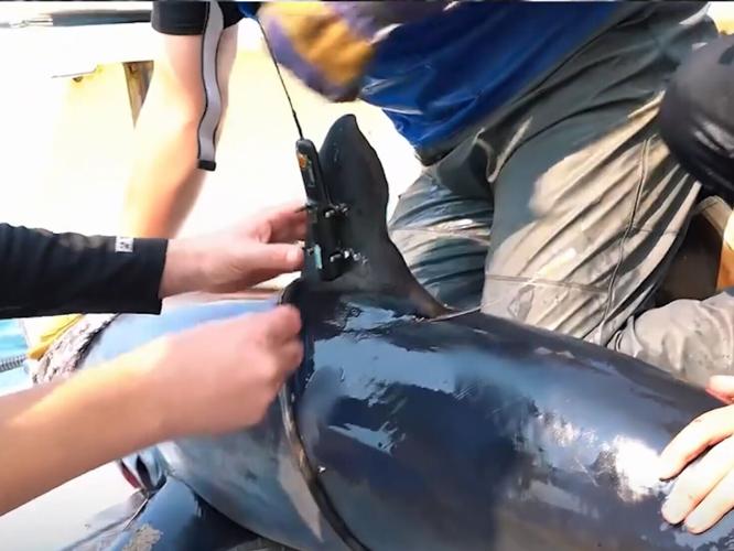
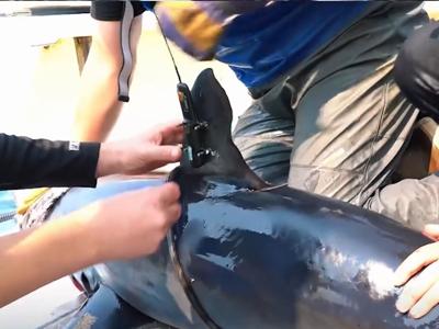
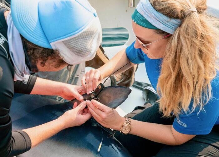
Neil Hammerschlag, Ph.D. and Laura McDonnell, Ph.D. attach a satellite tag to a blue shark that transmitted location, temperature, and depth data. (Nola Schoder / MPS via SWNS)
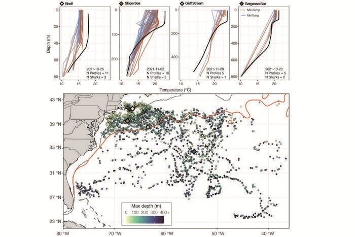
Example shark-derived temperature-depth profiles across four regions, with the distribution of all transmitted profile locations (October 2021 - April 2022). Top panels compare tag-derived profiles within a 1° × 1° grid cell on a given day to the concurrent control (CFSR) profile (black), with shark tag data showing minimum (blue) and maximum (red) temperatures. Summary statistics for each grid cell are provided in-panel. The bottom map shows all profile locations and maximum depths (N = 8,242), with colored diamonds marking example profiles, orange lines indicating the Gulf Stream, and the black line marking 200 m depth. (Dr. Laura McDonnell via SWNS)
Neil Hammerschlag, Ph.D. and Laura McDonnell, Ph.D. attach a satellite tag to a blue shark that transmitted location, temperature, and depth data. (Nola Schoder / MPS via SWNS)
By Talker
By Stephen Beech
Sharks may help improve climate forecasts, according to a new study.
Electronic tags fitted to the fearsome predators can serve as mobile sensors – collecting ocean climate data in regions that are difficult to observe using conventional methods, say scientists.
Research demonstrated how animal-borne sensors can work in tandem with traditional tools to improve ocean predictions.
The findings, published in the journal npj Climate and Atmospheric Science, showed that temperature and depth data gathered by tagged sharks can enhance ocean forecast accuracy in the Atlantic.
By incorporating shark-collected data into a seasonal climate model, the research team found that forecast errors at the ocean surface decreased substantially in certain regions, with improvements reaching as much as 40% in some cases.
The study is the first to experimentally integrate animal-borne sensor data into a seasonal climate model and quantify its impact on forecast performance, suggesting potential for future operational use.
Example shark-derived temperature-depth profiles across four regions, with the distribution of all transmitted profile locations (October 2021 - April 2022). Top panels compare tag-derived profiles within a 1° × 1° grid cell on a given day to the concurrent control (CFSR) profile (black), with shark tag data showing minimum (blue) and maximum (red) temperatures. Summary statistics for each grid cell are provided in-panel. The bottom map shows all profile locations and maximum depths (N = 8,242), with colored diamonds marking example profiles, orange lines indicating the Gulf Stream, and the black line marking 200 m depth. (Dr. Laura McDonnell via SWNS)
By Talker
Study leader Laura McDonnell said: "Sharks are already moving through parts of the ocean that are challenging for us to observe.
"This research shows that data they collect can help fill important gaps and, when used carefully, can improve how we predict ocean conditions."
They recognized in 2018 that the data from shark-tagging studies used by Hammerschlag's lab to examine shark ecology could also benefit climate modeling.
Satellite tags attached to sharks record depth and temperature as they travel through the ocean, collecting and transmitting this data in near real time.
While the tags have long helped scientists track shark movements, the collaboration opened a new application and a chance to create a novel proof of concept: using the same data to improve climate forecasts.
Kirtman said: "Marine predators like sharks naturally seek out dynamic ocean features such as fronts and eddies.
"These are areas where models often lack sufficient observations."
Supported by a grant from technology firm Cisco Systems, the team conducted fieldwork and tested the concept.
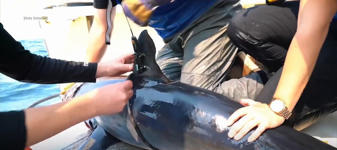
A sensor is attached to a shark. (Nola Schoder / MPS via SWNS)
By Talker
McDonnell and Hammerschlag tagged 18 blue sharks and one shortfin mako shark in the Northwest Atlantic.
The sharks transmitted more than 8,200 temperature-depth profiles across a range of locations and depths down to nearly 2,000 meters (6,500 feet).
Study co-author Camrin Braun helped enable the field work off Cape Cod by connecting McDonnell and Hammerschlag with a local fisherman and co-led the forecast data analysis.
Hammerschlag, executive director of the Shark Research Foundation, said: "Key to this study was repurposing a more advanced tag capable of transmitting location data along with temperature and depth information.
"This allowed us to link subsurface ocean conditions directly to specific locations with known accuracy."
Kirtman integrated a subset of the data into the Community Climate System Model, a coupled ocean–atmosphere–ice–land model used in seasonal forecasting applications.
The team compared the actual resulting climate conditions with the forecasted predictions from traditional models as well as the ones that integrated the shark collected data.
The results showed "measurable improvements" in forecast performance, particularly in dynamic coastal and shelf regions that are important for marine ecosystems and fisheries.
The researchers emphasize that animal-borne sensors are not a replacement for traditional observing systems but a complementary tool.
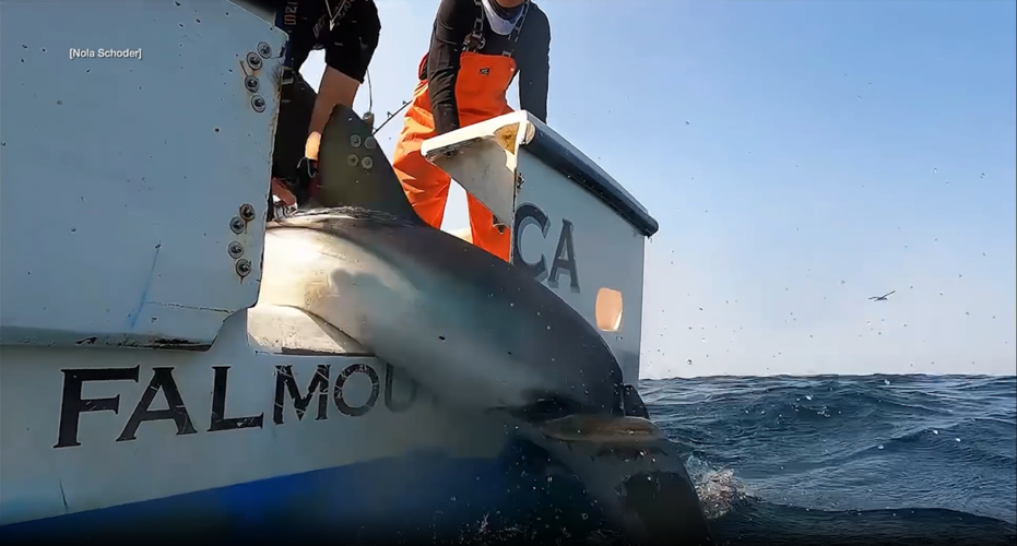
A shark is released back into the ocean after a sensor was put on it. (Nola Schoder / MPS via SWNS)
"What the preliminary results do show is that tagged marine predators can provide complementary in-situ observations at the surface and at depth."
She says accurate ocean forecasts are critical for fisheries management, marine operations, and understanding how climate variability affects coastal communities.
But forecasts are often least reliable in regions where conditions change rapidly and observational data are lacking.
The researcher say animal-borne sensors could enhance predictions that support decision-making across multiple sectors, from seafood supply chains to climate adaptation planning.
Hammerschlag said: "Marine animals are already being tracked to understand their behavior in relation to environmental conditions, but this study reveals how these data can also be leveraged for forecasting and climate applications."
Braun added: "For fisheries and coastal communities, small improvements in ocean forecasts can make a big difference.
"Reducing uncertainty helps people plan, whether that's where to fish, how to manage resources, or how to respond to changing conditions."


Commented