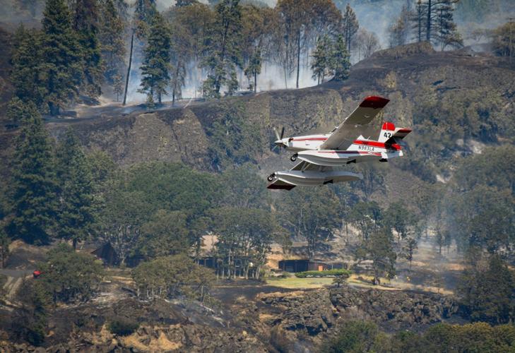
A “Fire Boss” aircraft had come off the river after scooping up water and in the background a crew of three firefighters were working on making a fire break around a home.
A “Fire Boss” aircraft had come off the river after scooping up water and in the background a crew of three firefighters were working on making a fire break around a home.
KLICKITAT CO. — The Klickitat County Sheriff’s Office (KCSO) has expanded the Level 3 — Go Now — Burdoin Fire evacuation on the northwest corner of the fire, it was reported in the afternoon of July 20. Containment remains at 0%
This section of the fire is continuing to burn northwest towards the Tracy Hill area (Major Creek and Bates Road), KCSO reported.
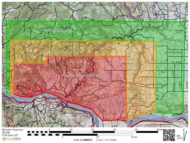
The evacuation map on July 20, updated at 1:30 p.m. For updated evacuation information, visit sartopo.com/m/0NL3FK3.
Contributed
The fire started on July 18 at 2:29 p.m. in the Bingen-Lyle area, according to Watch Duty. The estimated size is 8,776 acres.
Watch Duty also reported Sunday afternoon that steady winds and 25 mph gusts were expected to push the fire north and northeast on Sunday. Active up the Klickitat River drainage, Level 3 evacuations remain in place for Lyle and much of the surrounding area. More crews are arriving to help with the primary objective of protecting life safety, structures, property, and critical infrastructure, said a press release.
The fire is currently burning on both sides of Highway 14, which remains closed from mile marker 66, east of Bingen, to mile marker 76, west of Lyle. Other closures include Highway 142 from Highway 14 north to mile post 5, and Centerville Highway from Highway 14 to Centerville. Travelers should find alternate routes.
Ground crews continue to be supported by multiple aircraft, which are dipping water from the Columbia River. Recreationists in the area should be aware of fire activity and use of the waterway.
“Recreating in the fire area is prohibited,” said a Watch Duty press release. “Please be aware of all evacuation areas and closures. Accessing closed areas can impede the work of firefighters.”
The Southwest Washington Incident Management team took over command of the fire at 6:30 a.m. on July 19. Late that afternoon, the fire jumped the Klickitat River at Oliver Point and headed east, north of Centerville Highway, and spreading to Struck Road overnight.
Because of the complexity of the Burdoin Fire, Complex Incident Management Team-Northwest 13 is slated to arrive this evening (July 20) and assume fire management on Monday.
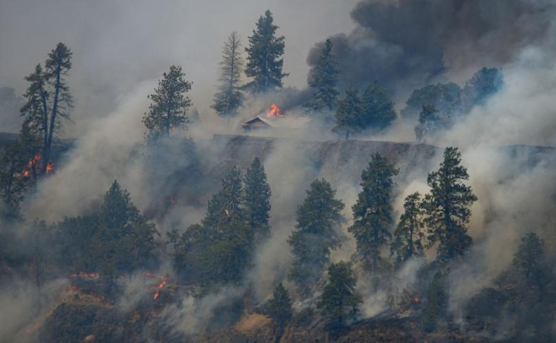
A home catches fire, and quickly becomes engulfed.
Gary Elkinton photo
“The larger team has significantly more overhead to manage current and incoming resources assigned to the fire,” said a Watch Duty report. “This will also assist with the span of control for resources and firefighters currently working on the fire.”
The Northwest Interagency Coordination Center (NICC) has reported that 250 residences are threatened, with 14 destroyed and 37 damaged. There are also 50 minor structures damaged, and another 30 have been destroyed.
“Structural protection and fighting the fire are high priorities as new resources arrive on the incident today [July 20],” said a NICC press release. “Aircraft will be actively operating in that area working to help control the fire spread and support ground resources. Ground crews will be working to secure the fire, anchoring to roadways and trails as available. Firefighting aircraft and crews are pulling water from the river, so Columbia River users should be alert to fire activity and resources in the area.”
Columbia High School’s C Court building off of NW Simmons Road in White Salmon is serving as an evacuation shelter, as is The Dalles Middle School, E. 12th Street. Livestock and animal evacuation, shelter assistance, and general questions can be directed to Klickitat County Emergency Operations Center at 509-773-0570.
An updated fire map, including evacuation levels, is online at sartopo.com/m/0NL3FK3.


Commented