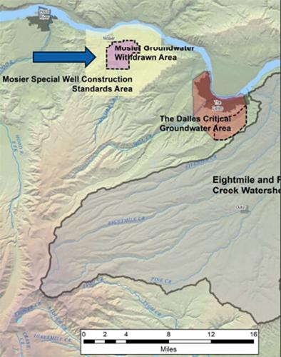
This map shows the Critical Ground Water Area (CGWA) for Mosier and Sevenmile Hill, listed as an area of concern by the Oregon Water Resources Department (OWRAD).
Fifteenmile / Eightmile basin. “About 50% of the total flow is lost between Dufur and a gauge near the mouth of Fifteenmile Creek in the dry months,” said District 3 Watermaster Robert Wood.
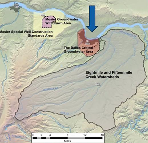
This map shows The Dalles Critical Ground Water Area (CGWA), listed as an area of concern by the Oregon Water Resources Department (OWRAD).
Image courtesy OWRAD District 3 Office
WASCO CO. — A state water manager painted a sobering but proactive picture of Wasco County’s water resources, detailing declining aquifers and efforts to monitor and protect supplies.
District 3 Watermaster Robert Wood presented an educational report to the Wasco County Board of Commissioners on March 5, highlighting critical water issues from the Mosier area to The Dalles and Dufur.
“Water is one of the most important issues we’ll be dealing with,” Commission Chair Scott Hege said, noting that he asked Wood to provide a baseline informational session to the board, which added a new member, Jeff Justesen, in January.
What is a water master?
Wood, an official with the Oregon Water Resources Department (OWRD), is based in The Dalles and oversees water management in District 3, which spans Wasco, Hood River and Sherman counties.
In this role, he regulates and distributes water rights during times of shortage, enforces water laws by investigating complaints, and collects data on streamflows and groundwater levels. He also inspects dams for safety and maintains water records and customer service in the region.
Oregon water law works on a seniority system, Wood explained, saying, “Water rights are based on a priority date as to when the water use was established.”
Wood said his office steps in to enforce those rules in dry years. He noted that curtailments were not needed last year due to decent stream flows, but emphasized that “when shortages hit, we have to honor the priority system to keep it fair.”
Beyond allocating water, Wood’s team responds to disputes and concerns from the public. He described handling complaints ranging from illegal water withdrawals to neighbors impacting each other’s wells.
“We get calls from landowners that are concerned about a new pump or something that might be going on near their property,” he said. “We investigate those and see if there’s illegal use and work with the person to try to resolve the issue.”
Equally important is data collection: Wood’s staff monitors stream gauges, checks well water levels and tracks usage with flow meters as well as inspecting dams.
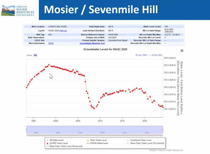
Wood’s report focused on several problem areas in Wasco County. Topping the list were the Mosier and Sevenmile Hill areas on the county’s west side, where groundwater levels have been falling since the 1980s.
This map shows the Critical Ground Water Area (CGWA) for Mosier and Sevenmile Hill, listed as an area of concern by the Oregon Water Resources Department (OWRAD).
Image courtesy OWRAD District 3 Office
Wood attributed the declines to heavy pumping for irrigation and to older wells that “commingle” aquifers, effectively connecting deep and shallow groundwater layers, causing leaks and draining.
When a well is drilled improperly through multiple aquifers, water can flow freely underground or be pulled from one layer to another when pumped, leading to a drop in pressure and water levels in the higher aquifer.
“Well construction is a major issue leading to declines in that area,” Wood said, citing a U.S. Geological Survey study of Mosier’s groundwater that linked poorly sealed wells to the problem.
State regulators took action as far back as the late 1980s once they realized aquifers were shrinking near Mosier. In 1988, Oregon withdrew two key aquifers, the Pomona and Priest Rapids formations, from any new water rights appropriations in the Mosier basin. Only smaller-scale “exempt” uses, such as household wells or stock water, can still siphon from those aquifers.
Image courtesy OWRAD District 3 Office
More recently, the state enacted special well construction rules for the Mosier and Sevenmile Hill area to prevent future wells from exacerbating the issue. Wood explained that under these rules, anyone drilling a new well or repairing a pump must install sealing in the well to prevent commingling and a dedicated measuring tube inside the well. This allows water levels to be easily measured and monitored over time.
Just as importantly, modern wells must be constructed to seal off separate aquifer zones, stopping unintended commingling.
“We’re making sure new wells don’t leak water between layers,” he said, adding that improved designs will help protect the shallower groundwater that domestic users rely on.
Two streamflow gauges — one operated by OWRD and one by the U.S. Geological Survey — keep watch on local creek levels, and a network of observation wells are measured quarterly by state staff out of The Dalles and Salem.
Wood noted that additional spot measurements are taken at landowners’ request, especially if someone’s domestic well starts having issues.
The Dalles: Shifting city use, aquifer storage
Turning east to The Dalles, Wood discussed another long-monitored area: The Dalles Critical Groundwater Area (CGWA), which encompasses aquifers underlying the east end of town and surrounding farmland. The state declared this area a critical groundwater zone back in 1959 due to significant drops in the water table.
No new water rights have been issued for the basalt aquifers in The Dalles CGWA since 1959, according to Wood. That means for more than 65 years, no farm or developer could get a new permit to pump those local aquifers for irrigation or large-scale use. Only small domestic wells were generally allowed for new users, and even some of those have conditions.
Over time, some large historical water users in The Dalles area have scaled back or disappeared, which has helped ease the strain. Wood pointed out that a series of heavy-use wells that once served an old aluminum plant were abandoned years ago. More recently, the City of The Dalles has shifted its strategy for water supply. The city drilled two new municipal wells in the past few years to bolster its drinking water.
One of those wells is designed for Aquifer Storage and Recovery (ASR), essentially a groundwater bank. Excess treated water can be injected into the aquifer for storage, and later pumped out when needed.
The Dalles’ ASR well is still being fine-tuned and tested. Wood’s office is working closely with city utilities and engineers from the U.S. Geological Survey to monitor water levels and quality in that project. So far, data indicates the aquifer can accept and return water as planned, though the volume is limited.
The OWRD continues to require certain well owners in The Dalles CGWA to report their water use monthly, especially those with older rights grandfathered in, to ensure they’re not exceeding allowed amounts. That data, along with periodic water-level measurements, will guide any future changes to the area’s status.
South County: New dry wells emerging
South of The Dalles, in the Fifteenmile Creek and Eightmile Creek basins near Dufur, Wood described a more emerging concern.
“We’ve been noting groundwater declines throughout Fifteenmile basin for a number of years,” he prefaced.
At the same time, surface water in Fifteenmile Creek appears to be dwindling along a particular stretch. Wood shared data collected over 20 years showing the creek significantly losing flow as it runs through the middle of the basin in summer.
“About 50% of the total flow is lost between Dufur and a gauge near the mouth of Fifteenmile Creek in the dry months,” he said.
In practical terms, water that flows out of the foothills by Dufur is only half of what reaches the lower gauge roughly 24 miles downstream during late summer. Such a loss suggests water is seeping into the ground or being diverted along the way: likely a combination of both natural recharge into the aquifer and withdrawals for irrigation.
OWRD hydrologists suspect the creek is a “losing reach,” feeding the underlying groundwater in that segment. This isn’t necessarily bad in a wet year, but during drought it could mean streamflow effectively disappears, impacting farmers and fish.
“The city of Dufur has expressed concerns about their wells,” Wood said. “They have some artesian wells in town, and in those the pressure has been dropping off as well.”
Commissioner Phil Brady noted that some residents had expressed concerns about orchard water usage, but Wood said no new irrigation permits have been issued in this area since the early 2000s.
Unlike Mosier or The Dalles, the Fifteenmile/Eightmile area has not been closed off or declared a critical groundwater area — at least, not yet.
Wood explained that the geology in southern Wasco County is complex, with multiple stacked aquifers and fault lines that can compartmentalize water.
“It’s a challenge because we have many geologic structures, and we’re trying to figure out how they affect groundwater flow,” he said.
One suspected culprit in the Fifteenmile basin’s decline is the same issue seen in Mosier: commingling wells. Some older wells there were drilled through several aquifers and weren’t properly sealed, meaning they might be allowing water to drain from one layer to another.
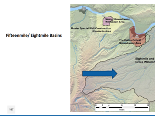
Fifteenmile / Eightmile basin. “About 50% of the total flow is lost between Dufur and a gauge near the mouth of Fifteenmile Creek in the dry months,” said District 3 Watermaster Robert Wood.
Image courtesy OWRAD District 3 Office
Studying South County’s declining groundwater
OWRD is currently studying the Fifteenmile basin’s water dynamics in partnership with the U.S. Geological Survey, launching an investigation into the groundwater decline.
“Is it due to pumping too much, commingling, or both? That’s the big question,” Wood said.
By spring 2025, the department plans to share the draft study plan with the community and incorporate feedback, and by fall 2025, intensify monitoring efforts on the ground. That will likely include installing new observation wells or measuring sites in strategic locations to study both groundwater and surface water.
In the meantime, Wood highlighted an initiative to expand the water monitoring network in the Fifteenmile watershed immediately. The agency has acquired 10 new totalizing flow meters and is offering them free to area landowners who volunteer to have their wells or irrigation systems metered.
“We have 10 meters ready to install at no cost for anyone willing to help us gather more data,” he said.
At the same time, surface water gauges are keeping close watch on streamflows. Several continuous stream gauges have been installed or reactivated on Fifteenmile Creek and its tributaries.
These gauges record water levels around the clock, and OWRD staff travel out monthly to manually verify the readings and measure flows, ensuring the instruments stay accurate. During high runoff events, they take extra measurements to capture those spikes.
“We want the community to be part of the process, especially in Fifteenmile where local knowledge can guide our study,” Wood said.
To facilitate that, the department will be updating the public regularly and has shared contact information for key staff, from hydrologists to well inspectors, working in Wasco County. Wood encouraged anyone with a water concern to reach out, whether it’s reporting a dry well or interest in the free meter program.
Hege said he hopes water-users in the county can take a more collaborative approach to addressing the groundwater supply, rather than focusing on who has the priority to the limited water that’s available.
“Hopefully we can help encourage people to come out to participate in that process, so that they are engaged in it and can work together, as opposed to battling each other,” he said.
If you are located in the Fifteenmile watershed and are interested in installing a free flow meter, contact the OWRD office in The Dalles at 541-506-2652 or robert.l.wood@water.oregon.gov.


Commented