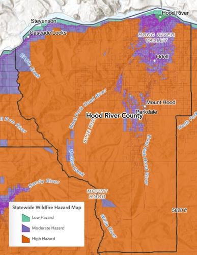
The new wildfire hazard map for Hood River County, created by the Oregon Department of Forestry and Oregon State University. While the previous version sought to identify wildfire risk across the state, which would require surveying each individual structure, this version focuses on the likelihood wildfires will occur and the intensity of those wildfires, or wildfire hazards.
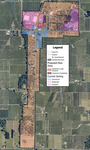
A graphic of the proposed zoning changes outlined in the Parkdale Community Plan. Under the plan, six separate lots will move from industrial to light industrial designations, allowing for both industrial and commercial uses, and five lots will become residential rather than industrial to provide space for more future housing.
HOOD RIVER — On Aug. 19, the Hood River County (HRC) Board of Commissioners heard presentations on efforts to prevent driving under the influence of intoxicants (DUII) and the state of countywide transportation infrastructure. They also pushed the Parkdale Community Plan forward and responded to a state-mandated wildfire hazard map, which was released in July.
The new wildfire hazard map for Hood River County, created by the Oregon Department of Forestry and Oregon State University. While the previous version sought to identify wildfire risk across the state, which would require surveying each individual structure, this version focuses on the likelihood wildfires will occur and the intensity of those wildfires, or wildfire hazards.
Image courtesy of ODOF and OSU
The Oregon Legislature passed Senate Bill 762 in 2021, an omnibus wildfire package that, in part, directed the Oregon Department of Forestry (ODF) and Oregon State University (OSU) to assess wildfire risk on properties across the state. When ODF and OSU delivered the first draft in June 2022; however, it garnered intense public outcry because many worried the risk designations would raise their insurance premiums.
The passage of Senate Bill 80 in 2023 put that problem to bed, but as County Community Development Director Eric Walker explained, the new iteration isn’t perfect either. Along with Jacob Edwards, the department’s geographic information systems (GIS) coordinator, Walker pinpointed 349 county parcels they felt ODF and OSU inaccurately labeled for two main reasons.
“One was that it included some remaining orchard land that continued to be identified as high [hazard],” said Walker, even though perennial crops require consistent irrigation during wildfire season. “Two, there was a number of anomalies or islands of property rated as high [hazard] that were surrounded by moderate [hazard] properties, or vice versa, with no apparent differences in the landscape.”
When Walker and Edwards brought attention to the disputed parcels back in April, ODF and OSU only changed the hazard designation of 10 parcels. The board decided that Commissioner Leticia Moretti would attend an Association of Oregon Counties meeting on Aug. 26 (after press deadline) to further advocate those changes and help mitigate distrust in the new map.
A graphic of the proposed zoning changes outlined in the Parkdale Community Plan. Under the plan, six separate lots will move from industrial to light industrial designations, allowing for both industrial and commercial uses, and five lots will become residential rather than industrial to provide space for more future housing.
Image courtesy of Hood River County
The board also agreed to move forward with the draft Parkdale Community Plan as recommended by the County Planning Commission in July. Directed by Oregon’s Unincorporated Communities Rule, HRC began building a plan for Parkdale in 2002 but never completed it because of wastewater treatment capacity issues. Efforts picked back up in 2022, and after a community meeting, survey and information sessions, the plan is nearing its final stages.
“Some of the overall objectives we’ve been working under are preserving rural character and agricultural heritage in the area, in part by focusing on managing future growth,” said Matt Hastie, a project manager at planning company MIG, Inc.
According to Hastie, the 287 English-speaking survey respondents see single-family homes and accessible dwelling units as the two most needed types of housing, and 66% do not believe there’s a need for more businesses. Of the 40 Spanish-speaking respondents, half hoped to see apartments or condos in Parkdale, and 80% reported a desire for more local businesses. At a community open house in October 2023, Hastie said there were conflicting feelings about expanding the wastewater treatment plant, a precursor for future growth.
As such, Hastie recommended several zoning changes, all from either industrial to light industrial or industrial to residential, opening up more spaces for potential businesses and housing. Regarding wastewater, the existing system can support an additional 32 “equivalent dwelling units,” and there are no plans for upgrades.
After Hastie finished presenting the draft, the board discussed a very specific topic at length: Short-term rentals. Essentially, the current zoning ordinance does not allow short-term rentals — think of an Airbnb rather than a bed and breakfast — in residential zones but does in commercial zones. The board considered whether more restrictions were necessary.
“I think as commissioners, valuing housing for people that work and live here, that we would be making [a] statement by really making sure we’re closing that loophole and putting up those boundaries,” said Moretti.
“I would agree too,” said Commission Chair Jennifer Euwer. “I do think that is how many people that live there do feel.”
Ultimately, the board decided to read the draft during its next meeting on Sept. 16 and hold a public hearing in October as originally planned. If there’s clearly a desire from Parkdale residents to establish stricter guidelines for short-term rentals during the hearing, however, the board agreed to amend the ordinance.
Next, Hood River’s Public Works Department updated the commissioners on road and other transportation infrastructure repairs. The presentation came amidst both a local and statewide lack of funding: Due to diminishing fees and taxes, Oregon’s Department of Transportation (ODOT) requires an extra $1.8 billion annually to perform basic maintenance, according to Oregon Public Broadcasting.
By comparison, HRC receives around $3.1 million from various revenue sources while burning $3.6 million annually. Even though HRC has 190 miles of paved road, the county only repaired 7 miles in the last year, and the status of all county bridges, road signs, road striping and culverts is unknown.
“That’s about 28 years to maintain all of our roads, and I would imagine that the overall life of a road is less than that,” said Commissioner Ed Weathers. “I’m just highlighting the fact that we’re way behind given our current resources, and that will only get worse.”
Beginning in June, the state’s Joint Commission of Transportation has visited several cities to gather public input on how to solve ODOT’s funding woes in the 2025 legislative session. Either Euwer or Moretti will attend the Sept. 13 meeting in The Dalles to represent HRC’s interests.
Lastly, the board heard a presentation from Hood River’s Prevention Department on their strategies to reduce inebriated driving, and key metrics on DUII arrests. Officers made 411 DUII arrests in 2023, around 30% of those arrests were repeat offenders and marijuana as a primary or secondary substance continues to grow.
Around one-third of those arrested had their last drink at home or a friend’s house, followed by Whiskey Tango and Red Carpet. Overall, the prevention department emphasized a need for more accurate, easily accessible data to adequately determine what’s working and what isn’t.
Correction: Jacob Edwards, Hood River County geographic information systems (GIS) coordinator, was misidentified in the Aug. 28 print edition, as was his title. The 2023 Senate Bill was also misidentified; it should have read Senate Bill 80. We regret the errors.


Commented
Sorry, there are no recent results for popular commented articles.