
WASCO CO. — Stopping long-term, deep declines in groundwater in the Fifteenmile watershed is the goal of a study by Oregon’s Water Resources Department (OWRD) over the next few years, as reported at an OWRD public hearing at Dufur School this June.
Groundwater in the area drained by Fifteenmile and Eightmile creeks — a basin of dry ridges, wheat fields, small vernal streams and occasional springs around the town of Dufur — has been dropping steadily since data collection began in the 1980s.
Restoring groundwater can take generations, but how long it’ll take here is unknown, Groundwater Manager Justin Iverson said.
OWRD is responsible for collecting, analyzing and sharing data, which they also use to update water rights and requirements. If the decline isn’t halted, the area could get a Critical Groundwater Area designation, restricting water use.
Critical groundwater areas are OWRD’s only way to “reduce groundwater use by priority in a given area.” Fifteenmile was the OWRD’s third priority in Oregon under a plan published in 2017. The City of The Dalles has been a critical groundwater area for decades.
For now, OWRD has cost-sharing funds available for water meters, a dry well reporting webpage, and staff gathering data for a careful evaluation. They hope to pinpoint the cause of groundwater decline.
Possible causes of the decline include a reduction in water entering the basalt layers at a higher elevation; co-mingling wells; too much water being pumped out of the aquifer; or a combination of those things.
There’s also the “losing reach” of Fifteenmile Creek, where up to 50% of the stream’s water vanishes from the surface for unknown reasons.
Dufur’s geology includes broad, flat layers of Columbia River basalt, which trap groundwater aquifers between them. Geologic faults in the rock can allow groundwater to move between aquifers.
So can deep “co-mingling” wells drilled through multiple aquifers, which have been a problem in the Mosier area. They could be a potential source of water loss in the Dufur area, too.
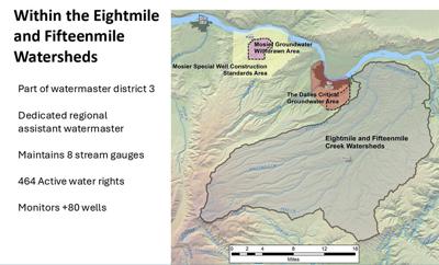
About 80 stream gauges and 464 water rights are active here. OWRD staff have two precipitation gages and hope to install another. OWRD contracted with the U.S. Geological Survey to map the area’s geology. Staff will also take samples of groundwater from wells, analyze the trace minerals and carbon date the water to learn how long it took to move between the basalt from where it entered. They collect rock chips during the drilling of wells and analyze them to figure out what rock formations the well passes through.
They’ll also evaluate evapotranspiration — how much water evaporates from plants — using satellite and temperature data. It’s a sturdy system that the Bureau of Reclamation also uses, and “a lot of folks use it for things like figuring out how much water you need in different areas of the Western U.S. to grow crops,” Iverson said.
Surface water in Fifteenmile and Eightmile comes from rain and snowmelt flowing off Mount Hood. In the summer, when the snow has melted and rain is sparse, the remaining springs and streams are fed by groundwater seeping out from the basalt.
Shallow wells near Fifteenmile Creek have not declined — probably because they get enough surface water from Fifteenmile to compensate for the groundwater decline, said Bob Wood, District 3 Water Master. Deep wells, which access aquifers in the deepest basalt layer, the Grand Ronde formation, have declined steadily.
In the Eightmile area, well depth doesn’t matter — all the wells are declining at a fairly constant rate.
“It’s its own unique place. But we have these issues throughout the state,” noted Iverson.
Not everyone was happy to hear all that. “It seems like the study is too late for some us, whose well will probably dry completely this summer,” a resident told the presenters on June 5.
“I acknowledge that the timing is an issue,” said Iverson. “... What authorities we have from the legislature to effect a solution are this rule-making process that’s going to affect everybody in the area and we are choosing to ... get as much information as we can ... so that we can make a good choice.”
It will take several years to stabilize the groundwater declines in Fifteenmile, at least.
“There is no free lunch. You know, we can’t make water,” said Hydrologist Jon La Marche.
Resources for producers
Dry wells can be reported online at www.oregon.gov/owrd/programs/GWWL/Pages/drywell.aspx. Reported wells appear on a map, with personal information withheld from the public; OWRD staff can follow up on reports.
If a well goes dry from “acute interference” with a neighbor’s well, OWRD can regulate the junior water right involved.
OWRD has a cost-share program, where residents can install or replace flow meters for a 75% reimbursement. In-kind contributions can be counted for the other 25%. For this, contact Bob Wood at 541-506-2652 or robert.l.wood@water.oregon.gov.
•••
Local journalism needs your support. Subscribe to Columbia Gorge News at columbiagorgenews.com.


Commented