
White Salmon Valley Community Library was filled to the brim with people who had the desire to learn about the “History of Sculpting the Columbia River Gorge.”
Standing room only was the result of last Friday’s Wild About Nature talk led by Ellen Morris Bishop. Her presentation centered on the Columbia River’s evolution as it carved through the Gorge. The talk toured the various basalt flows, which swamped the area over the course of a few million years affecting the river’s path in the process.
Bishop, who now lives in Joseph, Ore., presented information she pooled from various geologists who had looked at the Columbia River Gorge’s assortment of gravel and wondered, “Where did all these other gravels come from?”
“When we look at the Columbia [River], it’s kind of like, well, there’s a river that’s always been there. That ain’t necessarily so,” Bishop said.
For the past 17 million years the Columbia River and its tributaries have shifted their courses in an intricate dance with the Columbia River Basalts, Bishop explained. Bishop pulled up a map of the Columbia River Gorge from 1853 and pointed out the improved knowledge of rivers since then. The map “fudged” the paths of the John Day and Lewis River.
Bishop highlighted four key northwest rivers, the Columbia, Snake, Clearwater, and Salmon River, which all interacted with the multiple basalt flows she would visit later in the talk. By looking at the river gravels of each river, the history and previous paths of each river could be identified, Bishop explained.
Before exploring the basalt flows Bishop addressed the Ice Age floods which helped form the Columbia River’s path. “Let’s go back a long time to the Cretaceous, or perhaps the Eocene,” said Bishop, “somewhere in the fuzzy nether land of between about 100 million years ago and 15 million years ago, or 16.8.”
Keeping that time period in mind, and then traveling to the “tippy-top” of the Wallowa Mountains, evidence can be found from the previous floods. “What you find are these giant quartzite boulders that are large,” Bishop noted. “They’re rounded, they have procession marks, which means they were rolled around in a river and smacked in to one another.”
Although the rocks provide evidence of a torrent of rushing water, they don’t provide an indication of the time period for when the floods took place.
“To think of an ancient river system that flowed where the tops of the Wallowa Mountains are right now, kind of puts you in a setting that we want to deal with,” Bishop explained. “The reason these rivers [The Columbia, Snake, Clearwater, and Salmon River] had to change course is that, if you’re a flowing river and you put a basalt flow smack-dab in the middle of your channel, it’s unlikely that you’re going to be happy.”
“The chances are that you will go around it, and sometimes you will go around it by a very long distance,” noted Bishop.
Another factor which was responsible for altering the rivers’ flow was the changing landscape, specifically the wrinkling of the basin and range begins where folds began developing.
“The Columbia River Basalt is part of something known as a LIP, a large igneous province,” Bishop explained. “These are, up in between about 16.8 and 5.5 million years ago. All together the Columbia River Basalts comprise a volume of about 210,000 cubic kilometers. That’s enough basalt to girdle the Earth around the equator twice.”
“Or we could build a wall around the equator and just kind of keep everyone in South America down there,” Bishop joked.
The Columbia River Basalt is divided in to two groups, Bishop explained, the Steens Basalt and the Columbia River Basalts. The eruptions of the basalts began with the Steens Basalts in south eastern Oregon.
“These basalts erupted in four pulses,” said Bishop. The Imnaha Basalts erupted from 16.5 to 16.7 million years ago, then the Grande Ronde Basalts from 16.5 to 16.6, the Wanapum Basalts from 14.6 to 15.4, and finally the Saddle Mountain Basalts erupting from 6 to 14.6 million years ago.
All together there were about 90 major flows of basalt, Bishop said. The basalt flows started out slow but then gained momentum and covered the whole basin, altering the paths of the various tributaries it encountered.
“The Columbia River Basalts are really the earliest expression of the Yellowstone hotspot,” Bishop explained. The hotspot created delamination, which melted and peeled the bottom of the Earth’s crust allowing the magma to flow through crust fractures, resulting in large flows of basalt.
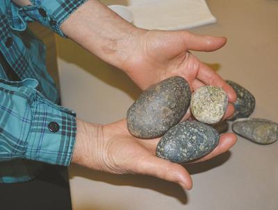
Bishop then explained some rock samples she brought along as evidence of the rivers’ past interactions with one another. “By putting this sort of recipe together, you have to figure out what the source area of these gravels are. So that’s one of the things that can inform us,” Bishop said.


Commented
Sorry, there are no recent results for popular commented articles.