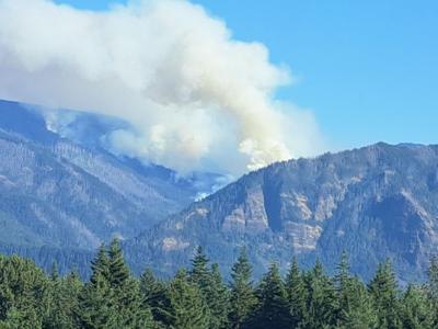
CASCADE LOCKS — Northern Rockies Complex Incident Management Team 2 Incident Commander Scott Schuster said in an Aug. 8 news release that the Whisky Creek fire, burning six miles southeast of Cascade Locks, has grown to 1,447 acres. It remains at 0% containment.
Schuster said today, Aug. 8, was expected to be one of the hottest days of the week, with wind gusts up to 25 mph. “Warmer and drier weather may increase fire intensity while east winds forecasted will increase smoke on the west side of the Gorge,” he said. “Fire activity and smoke production is expected in the afternoon as fine fuels dry and become more receptive to burning, but lighter winds should reduce rates of spread.”
Smoke forecasts specifically for the Whisky Creek fire area are available at AirNow.gov, he said.
He said crews made progress yesterday holding and securing the hard lines. “Today, crews will continue to improve existing handlines on the western side of the fire, and on the east and southeast flanks of the fire, crews will monitor and hold lines where firing operations were conducted. If conditions are favorable, firing operations to reduce fuels between the fire and control line will be conducted.”
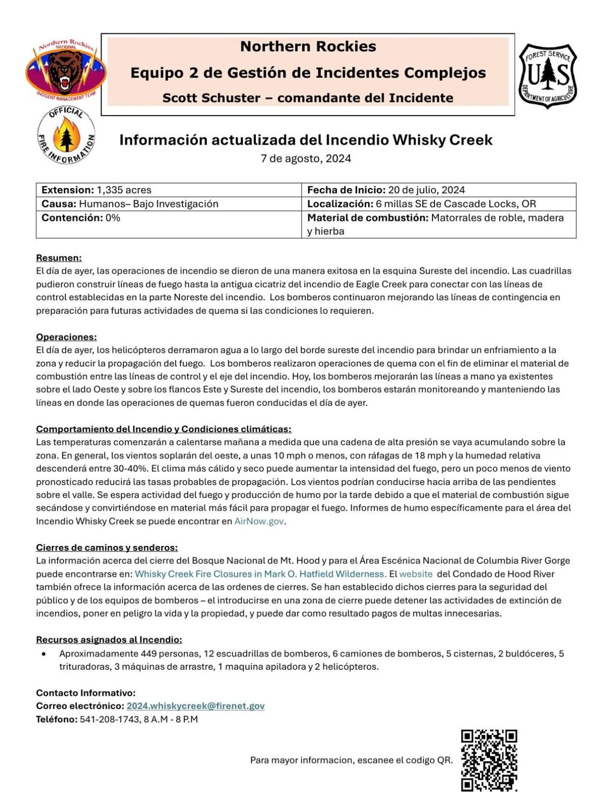
CASCADE LOCKS — The Whisky Creek fire, which began July 20, was reported to have grown to 1,335 acres Aug. 7. Containment is still at 0%. The human-caused fire is burning six miles southeast of Cascade Locks and is under investigation.
Northern Rockies Complex Incident Management Team 2 Incident Commander Scott Schuster said in an Aug. 7 news release that approximately 449 personnel, 12 hand crews, six engines, five water tenders, two dozers, five masticators, three skidders, one feller buncher and two helicopters are assigned to the fire, which is burning in scrub oak, timber and grass.
In the same news release, Schuster said today, Aug. 7, crews “will improve existing handlines on the western side of the fire, and on the east and southeast flanks of the fire crews will monitor and hold lines where firing operations were conducted yesterday.”
On Aug. 6, helicopters dropped water along the southeastern ridge of the fire the previous day “to cool the area down and reduce spread.” Those operations were successful, Schuster said.
The fire closure area is located in the Columbia River Gorge National Scenic Area and Mt. Hood National Forest lands inside the Mark O. Hatfield Wilderness boundary east of Eagle Creek Trail 440 and Indian Springs Trail 435. It also includes lands just east of the Mark O. Hatfield Wilderness and west of Flume Creek, and north to all forest lands just south of the State Trail. A number of Forest Service System roads and trails are also closed; see www.fs.usda.gov/Internet/FSE_DOCUMENTS/fseprd1196857.pdf for the full listing.
Remaining open are Wyeth Campground and the Gorge 400 trail connecting to Eagle Creek Trail 440 to the Bridge of the Gods trailhead, which allows access for Pacific Crest Trail hikers.
In Hood River County, the following trails and roads have recently closed due to the fire:
Post Canyon Rd. above 7 Streams Staging Area
Post Flats Staging Area
Mitchell Ridge
Mobius
Spaghetti Factory
Trail 133/Borderline
Trail-130/Whip snake
Blade Runner
Moto-Ghetti
“HRC Forestry has established closures and fire teams will be working through the area with heavy equipment establishing contingency fire lines,” reads the Hood River County Fire Season 2024 webpage (www.hoodrivercounty.gov/closures). “This closure is expected to remain in place until progress in containment of the fire is made. For the safety of all, do not approach machinery or enter closures. Hood River County Sheriff's Office is on patrol and enforcing this closure.”


Commented