
By Nathan Wilson
Columbia Gorge News
HOOD RIVER & WASCO CO. — With 33 structures destroyed, almost 94,000 acres burned and an estimated $50 million worth of recovery expenses in Wasco County, excluding suppression costs, a new preliminary report outlines damage caused by the Grasshopper Fire in greater detail.
As previously reported by Columbia Gorge News, Burned Area Emergency Response (BAER) personnel set down in the fire’s footprint on Sept. 14. Staffed with specialists in forestry, hydrology, soil science, geology and more, the team determines the need for, prescribes and sometimes implements emergency treatments to protect life, property and natural resources.
Officials with Mt. Hood National Forest will now use the report to prioritize repairs and request funding.
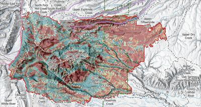
Their assessment found that only 3% of the fire’s area saw high soil burn severity, with 26% designated as moderate. Soil burn severity not only measures the land’s ability to support future plant life, but also to absorb water.
“Headwater watersheds with a sufficient portion of moderate to high soil burn severity may experience amplified peak flows up to 11 times greater than before the fire,” the report states. “Downstream communities, including Dufur, Wamic and Tygh Valley, may be affected by increased runoff and sediment from burned watersheds.”
The greatest impacts are anticipated during rain or rain-on-snow events from January through March, and the quality of surface water sources that The Dalles relies on for its municipal supply may also worsen temporarily. Channels of Fifteenmile Creek, Badger Creek and the East Fork Hood River are most prone to potential debris flows.
About 20% of the total fire area was classified as having a high or very high soil erosion potential.
As for infrastructure, 19 miles of trails and 34 miles of roads face high risks of erosion, flooding, rockfall, runoff, falling trees and debris flows. Undersized or clogged culverts are particularly likely to cause failures on Forest Road 44 and along Engineer’s Creek.
Flag Point Lookout was lost in the fire, and Bonney Horse Camp, Bonney Crossing Campground, Little Badger Campground, Fifteenmile Campground and Badger Lake Campground all sustained some damage. Firefighters were able to protect Pebble Ford Campground, Eightmile Campground, Underhill Campground, Lower Eightmile Campground and Camp Baldwin, however.
The report specifically noted that infrastructure at Fifteenmile Campground will be threatened by post-fire weather events.
The BAER team recommended drainage improvements, installing warning signs at major road junctions and high-use areas, and new gates in places prone to debris flows, among many others provided to the Mt. Hood National Forest.
Watershed conditions are expected to stabilize with 3-5 years, and while dependent on multiple factors, ground cover generally takes the same amount of time to return.
•••
Our journalism needs your support. Read more and subscribe at columbiagorgenews.com.


Commented