
UPDATE: There will be a community meeting tonight at the Grange at 7 pm. Members from the fire team will be there to share information on the fire status, fire management objectives and the resources they have on hand at this time.
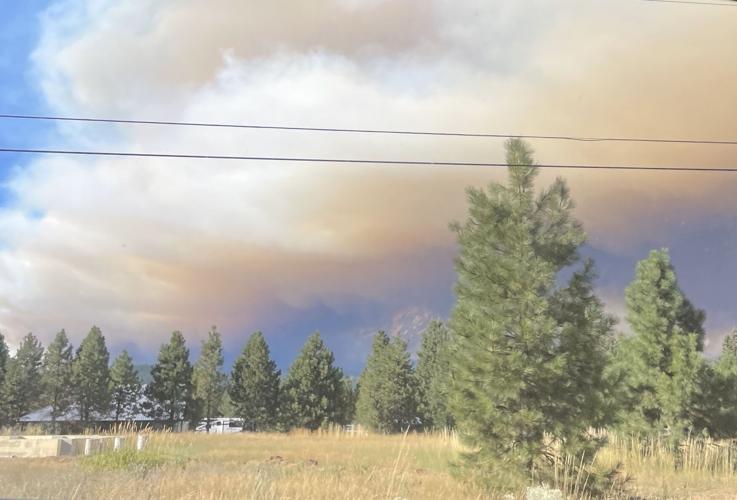
TROUT LAKE — Minnesota Incident Command Team C took command of the Williams Mine fire at 6 a.m. Aug. 8. The fire is now at 4,147 acres and remains at 0% containment, according Team C Incident Commander Jeb Backe in a news release.
Evacuation Levels 2 (Get Ready) and 3 (Go Now) are in effect for the community of Trout Lake. An evacuation center has been established at Columbia High School in White Salmon, 1455 NW Bruin Country Road. Evacuations are being coordinated by Klickitat and Skamania county sheriffs' offices.
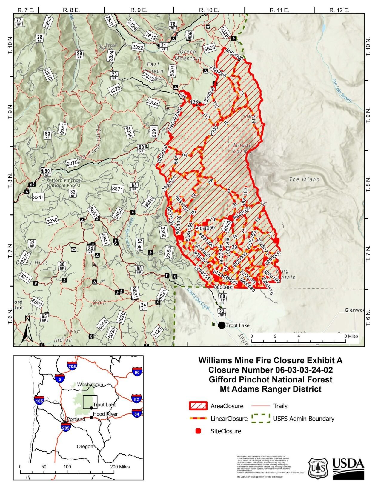
A forest closure is in effect for the entire Mount Adams wilderness and areas adjacent to the fire. The Pacific Crest Trail is closed between Williams Mine and Potato Hill, Backe said; additional information is posted on the Pacific Crest Trail Association website.
“The public is asked to avoid closure areas for their safety and safety of the firefighters,” he said.
Public use restrictions for fire are in place for the Gifford Pinchot National Forest: Building, maintaining, attending or using a fire, campfire or charcoal fire is prohibited outside of designated developed campgrounds.
Coordinating agencies and Tribes are Klickitat County Sheriff’s Office, Skamania County Sheriff’s Office, Washington Department of Natural Resources, Pacific Crest Trail Association, Bureau of Indian Affairs — Yakama Nation, Klickitat County and Skamania County.
From Gifford Pinchot National Forest — U.S. Forest Service:
Road Closures:
- NFS Road No. 2300 from its origin at the southern boundary of the Gifford Pinchot National Forest to its junction, and all spur roads.
- NFS Road No. 2309 from its origin off NFS Road No 2300 to its Junction with FS Road 5603.
Trail Closures:
- PINE WAY #71
- TAK TAK MEADOW #136
- TABLE MOUNTAIN #18
- WICKY CREEK #38
- HIGH CAMP #10
- RILEY SOUTH #64A
- SOUTH CLIMB #183
- PCNST #2000
- MUDDY MEADOWS #13
- ROUND THE MOUNTAIN #9
- SNIPES MOUNTAIN #11
- HIGHLINE #114
- GOTCHEN CREEK #40
- SALT CREEK #75
- STAGMAN RIDGE #12
- SHORTHORN #16
- TAKHLAKH LOOP #134
- WICKY SHELTER #19A
- BIG TREE XC LOOP -SNO-R8020
- COLD SPRINGS #72
- CROFTON RIDGE #73
- LOOKING GLASS LAKE #9A
- WHITE SALMON RIVER #54A
- DIVIDE CAMP #112
- KILLEN CREEK #113
- BUCK CREEK #54
- RILEY CAMP #64
- MORRISON CREEK #39
- BIG TREE #51
For more information and full Forest Closure Order: https://www.fs.usda.gov/alerts/giffordpinchot/alerts-notices and https://www.fs.usda.gov/main/giffordpinchot/fire.
Aug. 7
TROUT LAKE — A new forest fire was reported 3.5 miles north-northwest of Trout Lake Aug. 6 after a lightning storm passed through the area in the evening.
The Williams Mine fire is in the Mt. Adams Wilderness area, inside the Gifford Pinchot National Forest. InciWeb reports the fire is at 2,712 acres and is 0% contained.
Columbia Gorge Fires has a fire assistance page set up on Facebook; visit https://www.facebook.com/groups/244515122592421 for information on available evacuation space for livestock and/or humans as.
At 12:06 p.m., the fire was reported in the Trout Lake Horse Camp and heading directionally towards the town of Trout Lake.
Evacuation levels as of this morning have not changed: North and east of Trout Lake is at Level 3 (Go Now); west and south Trout Lake is at Level 2 (Get Ready).
The Pacific Crest Trail is closed from Williams Mine to Potato Hill and a formal closure order is in progress for the entirety of the Mt. Adams Wilderness area, including South Climb, and Forest Service Road 23, according to Klickitat County 911 Dispatch / Emergency Management (facebook.com/KlickitatDEM911).
An American Red Cross shelter has been opened at Columbia High School, 1455 NW Bruin County Road, White Salmon. Pets are welcome (bring your own crates and food; if you do not have those items, they will try to help find them).
“Multiple fires continue to burn across the Pacific Northwest region,” Klickitat County 911 Dispatch / Emergency Management reported on their Facebook page. “Fire restrictions are in effect on the Gifford Pinchot National Forest. Building, maintaining, attending, or using a fire, campfire or charcoal fire is prohibited outside of designated developed campgrounds.”
For additional fire information, please the Gifford Pinchot National Forest website at Gifford Pinchot National Forest — Fire Management (usda.gov) or on Facebook at @GiffordPinchot.
Updated information on this fire can be found at inciweb.wildfire.gov/incident-information/wagpf-williams-mine-firegpnf.


Commented
Sorry, there are no recent results for popular commented articles.