THIS UNDATED handout image provided by the US Geological Survey (USGS) shows where the earthquake hazard rates increased and decreased from 2008 report.
THIS UNDATED handout image provided by the US Geological Survey (USGS) shows where the earthquake hazard rates increased and decreased from 2008 report.
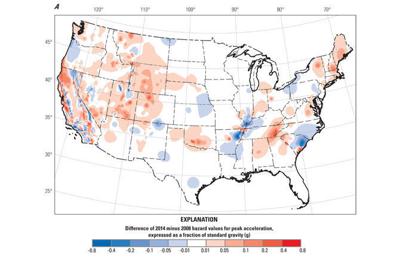
WASHINGTON (AP) — A new federal earthquake map dials up the shaking hazard just a bit for about one-third of the United States and lowers it for one-tenth.
The U.S. Geological Survey on Thursday updated its national seismic hazard maps for the first time since 2008, taking into account research from the devastating 2011 earthquake and tsunami off the Japanese coast and the surprise 2011 Virginia temblor.
The maps are used for building codes and insurance purposes and they calculate just how much shaking an area probably will have in the biggest quake likely over a building's lifetime.
The highest risk places have a 2 percent chance of experiencing "very intense shaking" over a 50-year lifespan, USGS project chief Mark Petersen said. Those with lower hazard ratings would experience less intense swaying measured in gravitational force.
"These maps are refining our views of what the actual shaking is," Petersen said. "Almost any place in the United States can have an earthquake."
Parts of 16 states have the highest risk for earthquakes: Alaska, Hawaii, California, Oregon, Washington, Nevada, Utah, Idaho, Montana, Wyoming, Missouri, Arkansas, Tennessee, Illinois, Kentucky and South Carolina. With the update, new high-risk areas were added to some of those states.
Also, Colorado and Oklahoma saw increased risk in some parts and moved up to the second of the seven hazard classifications, he said.
There are major faults and quake hazards along the entire west coast, with an increased concern in the Cascadia region around Oregon. Southern Alaska, the big island of Hawaii, the Missouri-Tennessee-Arkansas-Illinois New Madrid fault area and Charleston round out the biggest hazard areas.
But shaking hazards are nearly everywhere.
Much of the country west of the Rockies, along with parts of Oklahoma and Tennessee and sections of central Arkansas, northern Alabama, Georgia, South Carolina, Indiana, Illinois, Ohio, Michigan, Virginia, New York and New England saw an increase in shaking hazards for small buildings like houses.
At the same time much of North Carolina, the northern tip of South Carolina, patches of Texas, New Mexico, Oregon, Utah, Nebraska, Arkansas, Kentucky, Tennessee, Ohio, Pennsylvania and New York saw hazard levels lower slightly. And using a different type risk analysis for tall buildings the shaking hazard in New York City dropped ever so slightly, Petersen said.
Petersen said the maps sidestep the issue of earthquakes created by injections of wastewater from oil and gas drilling in Oklahoma and other states, saying those extra quakes weren't included in the analysis. So far this year, nearly 250 small to medium quakes have hit Oklahoma.
Much of the research and cataloging was done by the nuclear industry in response to the quake and tsunami that crippled Japan's Fukushima reactor. And researchers at the University of California, Berkeley came up with a better model to simulate shaking, Petersen said.
"I see it as a big improvement," said Cornell University seismologist Rowena Lohman. "They brought in more information."


Commented