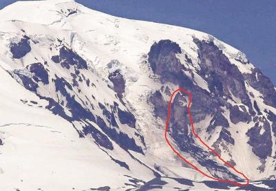
On June 6, Darryl Lloyd took a photo of the Klickitat Glacier located on the southeast face of Mt. Adams from Glenwood Valley. What the photo shows is that a large debris avalanche, or a Lahar, had taken shape not long ago.
As shown in the photo, the debris avalanche originated at about 10,400 feet as an ice and snow slab and can be seen down to about 8,800 feet. It is possible the avalanche’s track is much farther down however, and may extend down the northern edge of the glacier.
What prompted Lloyd to take the photo was that earlier, on May 24 the Klickitat river was noticeably muddier where it meets with the Columbia, which this time of year is usually pretty crisp and clear due to the snow melt on the mountains. When one thinks of the effects of avalanches, they don’t tend to think about the effects it could have on the rivers with all the debris that comes down from the mountain. They tend to think of big clouds of snow and ice rushing down a mountain side, ripping up trees and consuming everything in its path.
Fortunately when this particular avalanche took place, while there was noticeable destruction to be sure, it was not on a path toward any settled areas. It seemed to follow the path of the last avalanche on the southeast side, which happened on Oct 20, 1997, recorded as one of the biggest avalanches on Mt. Adams since the 1920s.
This would have been a catastrophic scene of destruction affecting the towns of Trout Lake, Husum, and BZ Corner had it been on the southwest side. The scientists at the United States Geological Survey (USGS) Volcano Hazards Program are monitoring the situation as to when they might begin to see avalanches happen on the southwest side of Mt. Adams.
If an avalanche of significant size were to happen on the southwest side of Mt. Adams, it would affect the aforementioned areas greatly. Apart from potentially major damage to homes and business, it could close off the White Salmon River to the Columbia, affecting the adventure tourism and shipping industries in those areas.
As of the latest 2017 assessment of the potential danger of a southwest avalanche, according to the USGS.gov there is a less than 1% chance of this happening in our lifetime. In fact the last time an avalanche of significance occurred on the southwest side of Mt. Adams was 6,000 years ago. That event played a role in forming what is now Trout Lake.


Commented
Sorry, there are no recent results for popular commented articles.